How to Find & Hire GIS Analyst
- Who GIS Analysts Are and Their Main Responsibilities
- 5 Benefits That a GIS Business Analyst Can Bring
- GIS technologies and tools used by GIS analysts
- GIS Analyst Responsibilities and Skills
- Requirements and qualifications for GIS analysts
- GIS Analyst Salary in Different Countries
- Mobilunity, a Reliable Provider of GIS Business Analyst Outsourcing in Ukraine
If you need to create geospatial data sets, prepare maps for publication and guide the GIS application development, then you are looking for a GIS data analyst. This spatial expert is technically minded, well-rounded, and has a wide variety of abilities.
In the article, you’ll learn more about skills, qualifications, GIS data analyst salary and what benefits a top level professional will bring to your business.


Who GIS Analysts Are and Their Main Responsibilities
GIS stands for geographic information system, a computer program that collects, stores, verifies, and presents information about locations on the surface of the Earth. GIS data analyst control the process of producing maps and graphical reports using relevant GIS tools. They manage data, undertake technological research and analysis, offer mapping services, and plan business activities. They may assist companies in better understanding geographical patterns and relationships by connecting seemingly unconnected data.
Analysts work together with other team members, like GIS developer and dedicated machine learning engineer, to determine the scope and timeline for projects. They are supposed to have in-depth understanding of Environment Rating Scales Institute (ERSI) solutions, be adept at data analysis, and effectively deliver data visualizations. GIS business analyst offers assistance and knowledge in building the company’s GIS capabilities to achieve strategic goals.
5 Benefits That a GIS Business Analyst Can Bring
With GIS software and GIS mapping it has become possible to work on environmental health concerns, reveal correlations between geographic location and environmental exposure, and provide easy access to crucial for life information, like the location of health institutions.
Also, the GIS data is important in making judgments regarding long-term planning and development in most areas like government, nongovernmental organizations and industries, including defense, meteorology, oil, gas, telecommunications, transport, and infrastructure.
As a result, GIS analysts who work with data play a significant role in the GIS industry.
- Utilize data extracted from GIS software and geographical analysis to discover patterns and trends, which helps stakeholders to make the best long-term decisions.
- Manage creating maps that display the spatial distribution of several types of data, such as crime rates and hospital locations, to give users a better knowledge of particular characteristics in a specific geographic area.
- Deliver images, maps, and charts to enhance the research, and suggest suitable and improved ideas in response to GIS analysis.
- Lead developing mapping apps knowing GIS software and technology.
- Administer and discover suitable choices for problem-solution, and suggest optimum resource allocation so the company can gain more benefits.
GIS technologies and tools used by GIS analysts
Applications for the map sciences are updated frequently to be compatible with new techniques for data processing and surveying. So, assessing and improving technical skill set and utilizing helpful tools regularly is important for GIS analyst remote to stay competitive on a market.
Several GIS technology and software analysts should constantly use it in their work.
- The Buffer Tool. A geoprocessing tool creates a polygon at a set distance surrounding the features. The buffer tool can have fixed and variable distances. Also, they can be set to geodesic which accounts for the curvature of the Earth.
- The Clip Tool. With it, an input layer is removed from an overlay function. This utility creates a new clipped layer as its output.
- The Merge Tool. GIS analyst uses this tool to combine the same data type data sets (points, lines, or polygons).
- The Dissolve Tool. With it, boundaries are unified using shared attribute values. In other words, if two borders next to each other share the same characteristics, dissolve merges them.
- The Intersect Tool. Because the output is determined by the extents of the input features, the intersect tool and the clip tool are quite similar. The one exception is that it keeps all of the output properties from data sets overlapping. Using the intersect tool, a geometric overlap can be done.
Various solutions, including desktop, web, and server, are used for GIS analysts. For instant,
- BatchGeo. Analysts may easily transform and change tabular geographic data (excel, CSV) into maps by using easy Copy/Paste or drag-and-drop features.
- ArcGIS. This cloud-based tool aids in unifying three-dimensional integration, map creation, sharing, collaboration, data analysis, and working with data.
- Cartodb. A cloud-based platform enables spatial analysis and transforms location data into clear reports. Additionally, it offers access to premium datasets through a data portal called Spatial Data Catalog.
- Global mapper. This program offers a variety of features, including data importing and exporting, an OTF reader module, printing and publishing of maps, terrain analysis, image rectification, graph and chart management, etc.
Using these tools, analysts examine and segment the data sets in accordance with predetermined standards.
GIS Analyst Responsibilities and Skills
Business analyst GIS uses their expertise to convey insights for various domains, such as assisting in urban development, environmental protection, and health areas.
The following are some examples of a GIS analyst’s primary duties, regardless of the industry they work in:
- Design and modify GIS data in accordance with client requirements
- Ensure data is aligned with company standard
- Digitalize paper maps into GIS data sets
- Monitor and examine all software contracts with technology suppliers
- Create staffing plans, budgets, workload projection reports, and departmental business strategies
- Check the stored data in the field to make sure it is accurate
- Manage database systems to support enterprise geodatabase hosting in terms of optimization, storage, security, and tracing
GIS analyst resumes should include a strong set of skills that prove the candidates are capable to do their jobs as effectively as possible:
- Expertise in data management and cartographic methods, with an eye for detail and independent quality assurance of drafts and deliverables
- Strong cartographic abilities
- Being able to multitask, perform in terms of deadlines, and produce quality outputs that meet client or industry standards
- Being meticulous, accurate, producing high-quality work, and taking ownership of it
- Strong organizational abilities to work in a team and independently
It is worth mentioning that both technical and soft GIS analyst skills should be important when considering candidates.
Requirements and qualifications for GIS analysts
Finding the ideal applicant entails finding a specialist who is driven and eager to advance their knowledge constantly. For starters, a GIS analyst resume should have at least the requirements below.
- A business, engineering, or GIS bachelor’s or graduate degree, or equivalent work experience
- Basic understanding of web development
- Knowledge of the following applications and systems: AutoCAD, CAD, Javascript, Agile, Qgis, GIS, SQL, Python, and Geo Database.
- Strong practical experience with spatial databases and GIS software (SQL spatial, PostgreSQL with PostGIS extension)
- Having knowledge of ArcGIS and other tools
Additional GIS analyst certification and licenses will be a big plus as they prove the level of knowledge. One of the most popular institutions that offers a certificate program is the GIS Certification Institute (GISCI). Through its global certification program, this non-profit organization supports the development of skilled GIS experts. The Institute promotes strict professional and ethical standards, community involvement, and expert mentoring within the GIS sector.
GIS Analyst Salary in Different Countries
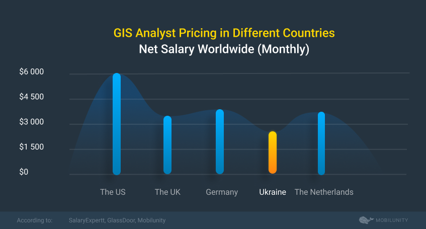
The wage range for a GIS specialist reflects the strong tech background and steep learning curve necessary for the profession. For instance, senior GIS analyst salary can be higher avarage due to their extensive knowledge and experience.
Regarding salary differences based on the candidate’s location, here is a table showing montly wages in 5 countries.
*Ukrainian salaries are provided based on Mobilunity’s Recruitment Team research on the local job markets. All salaries are net and do not include the service fee (in case of hiring on a dedicated team model). The salaries are provided for comparison purposes and could be not entirely accurate. Contact us to know the exact cost of hiring a developer corresponding to the required parameters.
As shown, the most reasonable average salary GIS analyst or GIS engineer gets is in the Ukrainian market, with the same level of expertise and devotion to projects.
Mobilunity, a Reliable Provider of GIS Business Analyst Outsourcing in Ukraine
Mobilunity, a Ukrainian company, offers global distribution. It provides a variety of collaboration formats, including advisory services and outstaffing for long-term and short-term projects. The business is recognized for its established procedures, extensive knowledge in the IT sphere, and client-focused philosophy.

Reasons why you can trust Mobilunity with finding and providing the best team work:
Outstanding reputation
Businesses from different countries, including Japan, Israel, the USA, Germany and many others, rely on Mobilunity experts. They include Pafin, Byrd, Zenchef, and Paidy. You can read their reviews on Clutch.co or the Mobilunity website.
Competent team
The organization developed competence in a variety of markets and business fields after 12+ years in business and 40+ successful projects. It offers top-notch software development services that completely satisfy the commercial requirements of clients.
Efficient communication
The remote teams’ collaboration is well-established throughout the years. It is top notch due to its high level of business ethics and transparent cooperation procedures.
Need to hire GIS analyst for your current or new project? Delegate Mobilunity to all recruitment and management tasks. Fill out the form on the website, and let’s discuss your requirements!


Disclaimer: All salaries and prices mentioned within the article are approximate numbers based on the research done by our in-house Marketing Research Team. Please use these numbers as a reference for comparison only. Feel free to use the contact form to inquire on the specific cost of the talent according to your vacancy requirements and chosen model of engagement.